Smithson
Contents
Smithson
|
Lat: 2.4°N, Long: 53.6°E, Diam: 5 km, Depth: 0.95 km, [/R%C3%BCkl%2037 Rükl: 37] |
Table of Contents

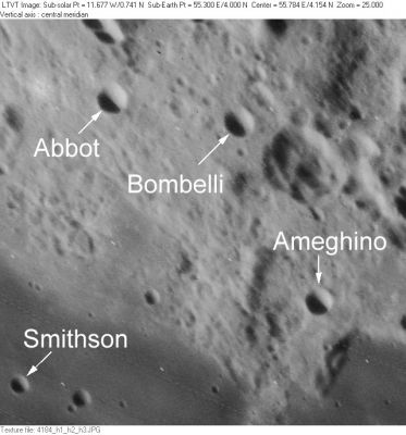
LO-IV-184H This small field straddling the northeast edge of [/Mare%20Fecunditatis Mare Fecunditatis] includes the four IAU-approved crater names [/Abbot Abbot], [/Ameghino Ameghino], [/Bombelli Bombelli] and [/Smithson Smithson]. The relatively large, complex crater to the southeast of [/Bombelli Bombelli] is [/Apollonius Apollonius] A.
Images
LPOD Photo Gallery Lunar Orbiter Images Apollo Images
- Apollo 10's AS10-35-5202 shows Smithson, Abbot, Bombelli, Ameghino, and Sinus Successus (and also the "Mishqui basin" near Abbot).
- AS10-31-4507 shows the distinct couple Smithson and Taruntius O'.
- Apollo 15's AS15-88-11964 shows craters Taruntius N (Smithson) and Taruntius O near the image's upper left corner, while part of Sinus Successus is behind Apollo 15's CSM Endeavour. Note the exposed SIM-bay in Endeavours Service Module.
- Smithson is also noticeable at the right part of Apollo 15's orbital ITEK-panoramic frame AS15-P-10116 (the distinct high-albedo crater), and on Apollo 16's ITEK-frame AS16-P-5219 (also near the right margin, with Taruntius O).
Research orbital Apollo 10 and Apollo 15 photography: Danny Caes
Maps
([/LAC%20zone LAC zone] 62D4) LAC map Geologic map LM map LTO map
Description
Description: Wikipedia
Additional Information
Depth data from [/Kurt%20Fisher%20crater%20depths Kurt Fisher database]
- Westfall, 2000: 0.95 km
- Viscardy, 1985: 0.43 km
Nomenclature
James; British chemist, mineralogist (1765-1829).
  The crater Smithson was formerly known as Taruntius N.
LPOD Articles
Bibliography
This page has been edited 1 times. The last modification was made by - tychocrater tychocrater on Jun 13, 2009 3:24 pm - afx3u2