Difference between revisions of "Rozhdestvenskiy"
| Line 6: | Line 6: | ||
|} | |} | ||
<div id="toc"> | <div id="toc"> | ||
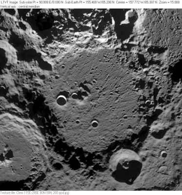
| − | [http://www.lpod.org/coppermine/displayimage.php?pid=3061&fullsize=1 [[Image: | + | [http://www.lpod.org/coppermine/displayimage.php?pid=3061&fullsize=1 [[Image:Normal_Rozhdestvenskiy_Clementine_LTVT.JPG|external image normal_Rozhdestvenskiy_Clementine_LTVT.JPG]]]<br /> ''[http://lpod.org/coppermine/displayimage.php?pos=-3061 Clementine]'' '''Rozhdestvenskiy''' is the large crater in the center of this north-up aerial view. The deep 42-km diameter crater on its southeast rim is '''Rozhdestvenskiy K''', while a little north of that on the rim is 21-km '''Rozhdestvenskiy H'''. The 109-km crater half visible in the lower left is [[Plaskett|Plaskett]] while the similarly sized, but less obvious, one in the upper right is [[Hermite|Hermite]]. Another named satellite, 44-km '''Rozhdestvenskiy U''', can be seen cut by the left margin (half way between the north rim of [[Plaskett|Plaskett]] and the top edge of the frame). The craters on '''Rozhdestvenskiy''''s floor are unnamed.<br /> <br /> |
==Images== | ==Images== | ||
[http://www.lpod.org/coppermine/thumbnails.php?album=search&type=full&search=Rozhdestvenskiy LPOD Photo Gallery] [http://www.lpi.usra.edu/resources/lunar_orbiter/bin/srch_nam.shtml?Rozhdestvenskiy%7C0 Lunar Orbiter Images]<br /> <br /> | [http://www.lpod.org/coppermine/thumbnails.php?album=search&type=full&search=Rozhdestvenskiy LPOD Photo Gallery] [http://www.lpi.usra.edu/resources/lunar_orbiter/bin/srch_nam.shtml?Rozhdestvenskiy%7C0 Lunar Orbiter Images]<br /> <br /> | ||
| Line 16: | Line 16: | ||
[http://en.wikipedia.org/wiki/Rozhdestvenskiy_(crater) Rozhdestvenskiy]<br /> <br /> | [http://en.wikipedia.org/wiki/Rozhdestvenskiy_(crater) Rozhdestvenskiy]<br /> <br /> | ||
==Additional Information== | ==Additional Information== | ||
| − | * Depth data from [[Kurt%20Fisher% | + | * Depth data from [[Kurt%20Fisher%20Crater%20Depths|Kurt Fisher database]]<br /> Westfall, 2000: 5.02 km |
* Measures on LRO QuickMap give max depth about 4 km | * Measures on LRO QuickMap give max depth about 4 km | ||
<br /> | <br /> | ||
Latest revision as of 03:13, 16 April 2018
Contents
Rozhdestvenskiy
|
Lat: 85.2°N, Long: 155.4°W, Diam: 177 km, Depth: 4 km, Rükl: (farside), pre-Nectarian |
Clementine Rozhdestvenskiy is the large crater in the center of this north-up aerial view. The deep 42-km diameter crater on its southeast rim is Rozhdestvenskiy K, while a little north of that on the rim is 21-km Rozhdestvenskiy H. The 109-km crater half visible in the lower left is Plaskett while the similarly sized, but less obvious, one in the upper right is Hermite. Another named satellite, 44-km Rozhdestvenskiy U, can be seen cut by the left margin (half way between the north rim of Plaskett and the top edge of the frame). The craters on Rozhdestvenskiy's floor are unnamed.
Images
LPOD Photo Gallery Lunar Orbiter Images
Maps
(LAC zone 1B4) USGS Digital Atlas PDF
Description
Description: Wikipedia
Additional Information
- Depth data from Kurt Fisher database
Westfall, 2000: 5.02 km - Measures on LRO QuickMap give max depth about 4 km
Nomenclature
- Named for Dmitriy Sergeevich Rozhdestvenskiy (1876-1940); Soviet physicist.
- Rozhdestvenskiy (then spelled Rozhdestvensky) was on the long list of farside names approved by the [IAU] in 1970 and published in Menzel (1971).
- Peter Lloyd's mountain (87.8 degrees north, 150 degrees west, on the rim of Rozhdestvenskiy). Mentioned by Peter Lloyd in Chuck Taylor's LUNAR OBSERVING group.
LPOD Articles
A New View of the Limb
North of the Pole
Ho Hum, Another Earthrise
Bibliography
