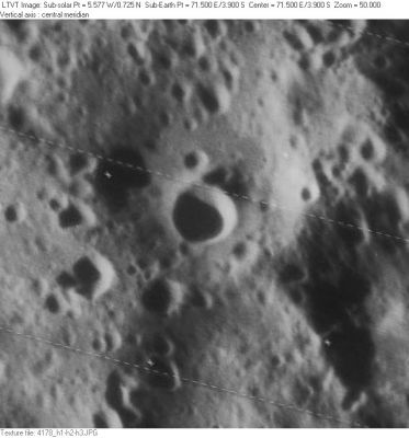
Rankine
Contents
Rankine
|
Lat: 3.9°S, Long: 71.5°E, Diam: 8 km, Depth: 2.7 km, Rükl: 49 |
Images
LPOD Photo Gallery Lunar Orbiter Images Apollo Images
- Because Rankine's location is at the floor of satellite crater Maclaurin B, all orbital Apollo photographs of it should be in the list of that crater (Maclaurin B).- DannyCaes Aug 22, 2010
- Apollo 16's panoramic ITEK-camera frame AS16-P-4394 shows Rankine's bright cone-shaped inner slopes a little bit beyond (to the right of) the frame's centre (rightward of the sun's bright retro-reflection at centre of the frame).
- Additional research: Danny Caes
Maps
Description
Description: Wikipedia
Additional Information
Depth data from Kurt Fisher database
- Westfall, 2000: 2.7 km
Nomenclature
- William John Macquorn Rankine (July 5, 1820 - December 24, 1872) was a Scottish engineer and physicist. He was a founding contributor, with Rudolf Clausius and William Thomson (1st Baron Kelvin), to the science of thermodynamics. He published several hundred papers and notes on science and engineering topics, from 1840 onwards, and his interests were extremely varied, including, in his youth, botany, music theory and number theory, and, in his mature years, most major branches of science, mathematics and engineering.
- The crater name Rankine was provisionally introduced on LTO-81A1, for which it serves as the title. Rankine is somewhat unique in that it lies entirely within the larger (43-km) "satellite feature" Maclaurin B. The interior crater now called Rankine did not formerly have a name.
LPOD Articles
Bibliography
