Difference between revisions of "Mare Insularum"
(Created page with "<div id="content_view" class="wiki" style="display: block"> =Insularum Basin= ''(unofficial name; IAU feature name for central 513 km of mare: '''Mare Insularum''' )''<br />...") |
|||
| (2 intermediate revisions by the same user not shown) | |||
| Line 4: | Line 4: | ||
{| class="wiki_table" | {| class="wiki_table" | ||
| | | | ||
| − | Lat: 7.5°N, Long: 30.9°W, Main ring diam: 600 km, Depth: km, [http://the-moon. | + | Lat: 7.5°N, Long: 30.9°W, Main ring diam: 600 km, Depth: km, [http://the-moon.us/wiki/R%C3%BCkl%2030 Rükl: 30]<br /> |
|} | |} | ||
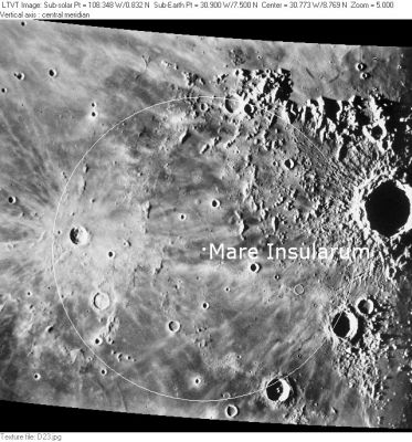
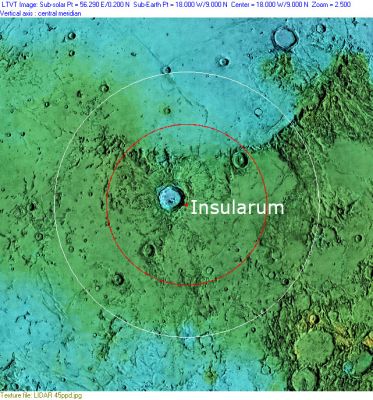
| − | [http://www.lpod.org/coppermine/displayimage.php?pid=2374&fullsize=1 [[Image: | + | [http://www.lpod.org/coppermine/displayimage.php?pid=2374&fullsize=1 [[Image:Normal_Mare_Insularum-CLA_D23-LTVT.JPG|external image normal_Mare_Insularum-CLA_D23-LTVT.JPG]]][http://www.lpod.org/coppermine/displayimage.php?pid=2376&fullsize=1 [[Image:Normal_Insularum-Basin_LIDAR_LTVT-Spudis_rings.JPG|external image normal_Insularum-Basin_LIDAR_LTVT-Spudis_rings.JPG]]]<br /> Left: ''[http://lpod.org/coppermine/displayimage.php?pos=-2374 Consolidated Lunar Atlas]'' (Plate D23) The white circle indicates the position and 513 km diameter of the IAU's Mare Insularum. The deeply shadowed crater on the right is [http://the-moon.us/wiki/Copernicus Copernicus] and the smaller rayed crater on the left is [http://the-moon.us/wiki/Kepler Kepler]. Right: ''[http://lpod.org/coppermine/displayimage.php?pos=-2376 Clementine LIDAR Altimeter]'', altitude-coded shaded relief from [http://pdsmaps.wr.usgs.gov/PDS/public/explorer/html/lidrlvls.htm PDS Map-a-Planet] remapped (like the CLA plate) to a north-up aerial view by [http://www.henriksucla.dk/ LTVT]. The dot is the center position and the red circle the main ring position from Chuck Wood's [http://www.lpod.org/cwm/DataStuff/Lunar%20Basins.htm Impact Basin Database]. The white circle shows the position of the 1000 km secondary ring. Note that the Insularum Basin is ''not'' centered on Mare Insularum, although it does contain most of it within the outer ring.<br /> <div id="toc"> |
| − | + | ||
| − | |||
==Images== | ==Images== | ||
[http://www.lpod.org/coppermine/thumbnails.php?album=search&type=full&search=Mare%20Insularum LPOD Photo Gallery] [http://www.lpi.usra.edu/resources/lunar_orbiter/bin/srch_nam.shtml?Mare%20Insularum%7C0 Lunar Orbiter Images] [http://www.lpi.usra.edu/resources/apollo/search/feature/?feature=Mare%20Insularum Apollo Images]<br /> The eastern and southern parts of '''Mare Insularum''' were photographed by the ''Fairchild'' mapping/metric camera aboard Apollo 16's SIM-bay. See the last frames of [http://www.lpi.usra.edu/resources/apollo/catalog/metric/revolution/?AS16R37 Revolution 37] (the region north of '''Fra Mauro''', sunrise terminator).<br /> Research Danny Caes<br /> <br /> | [http://www.lpod.org/coppermine/thumbnails.php?album=search&type=full&search=Mare%20Insularum LPOD Photo Gallery] [http://www.lpi.usra.edu/resources/lunar_orbiter/bin/srch_nam.shtml?Mare%20Insularum%7C0 Lunar Orbiter Images] [http://www.lpi.usra.edu/resources/apollo/search/feature/?feature=Mare%20Insularum Apollo Images]<br /> The eastern and southern parts of '''Mare Insularum''' were photographed by the ''Fairchild'' mapping/metric camera aboard Apollo 16's SIM-bay. See the last frames of [http://www.lpi.usra.edu/resources/apollo/catalog/metric/revolution/?AS16R37 Revolution 37] (the region north of '''Fra Mauro''', sunrise terminator).<br /> Research Danny Caes<br /> <br /> | ||
==Maps== | ==Maps== | ||
| − | ''([http://the-moon. | + | ''([http://the-moon.us/wiki/LAC%20zone LAC zone] 57C2)'' [http://www.lpi.usra.edu/resources/mapcatalog/LAC/lac57/ LAC map] [http://www.lpi.usra.edu/resources/mapcatalog/usgs/I355/ Geologic map] [http://www.lpi.usra.edu/resources/mapcatalog/AIC/AIC57C/ AIC map]<br /> <br /> |
| − | ==[http://the-moon. | + | ==[http://the-moon.us/wiki/Lunar%20Basins Basin Classification]== |
(description of terms and most numeric basin data from Wood, C.A. (2004) [http://www.lpod.org/cwm/DataStuff/Lunar%20Basins.htm Impact Basin Database])<br /> | (description of terms and most numeric basin data from Wood, C.A. (2004) [http://www.lpod.org/cwm/DataStuff/Lunar%20Basins.htm Impact Basin Database])<br /> | ||
{| class="wiki_table" | {| class="wiki_table" | ||
| Line 42: | Line 41: | ||
* The impact basin is named after the mare. | * The impact basin is named after the mare. | ||
| − | * With '''Mare Imbrium''' north of it, this region ('''Mare Insularum''') was called '''Mare Mediterraneum''' by Johann Hewelcke (Hevelius). See page 53 in E.A.Whitaker's ''Mapping and Naming the Moon'' for J.Hewelcke's moonmap (Figure Q) from 1647. <span class="membersnap">- | + | * With '''Mare Imbrium''' north of it, this region ('''Mare Insularum''') was called '''Mare Mediterraneum''' by Johann Hewelcke (Hevelius). See page 53 in E.A.Whitaker's ''Mapping and Naming the Moon'' for J.Hewelcke's moonmap (Figure Q) from 1647. <span class="membersnap">- DannyCaes <small>Mar 11, 2016</small></span> |
<br /> | <br /> | ||
==LPOD Articles== | ==LPOD Articles== | ||
| − | [http:// | + | [http://www2.lpod.org/wiki/July_5,_2004 Insularum Interlude]<br /> [http://lpod.wikispaces.com/March%2021%2C%202010 How thick are rays?]<br /> <br /> |
==Bibliography== | ==Bibliography== | ||
<br /> <br /> | <br /> <br /> | ||
---- | ---- | ||
| − | + | </div> | |
Latest revision as of 03:03, 16 April 2018
Contents
Insularum Basin
(unofficial name; IAU feature name for central 513 km of mare: Mare Insularum )
|
Lat: 7.5°N, Long: 30.9°W, Main ring diam: 600 km, Depth: km, Rükl: 30 |


Left: Consolidated Lunar Atlas (Plate D23) The white circle indicates the position and 513 km diameter of the IAU's Mare Insularum. The deeply shadowed crater on the right is Copernicus and the smaller rayed crater on the left is Kepler. Right: Clementine LIDAR Altimeter, altitude-coded shaded relief from PDS Map-a-Planet remapped (like the CLA plate) to a north-up aerial view by LTVT. The dot is the center position and the red circle the main ring position from Chuck Wood's Impact Basin Database. The white circle shows the position of the 1000 km secondary ring. Note that the Insularum Basin is not centered on Mare Insularum, although it does contain most of it within the outer ring.
Images
LPOD Photo Gallery Lunar Orbiter Images Apollo Images
The eastern and southern parts of Mare Insularum were photographed by the Fairchild mapping/metric camera aboard Apollo 16's SIM-bay. See the last frames of Revolution 37 (the region north of Fra Mauro, sunrise terminator).
Research Danny Caes
Maps
(LAC zone 57C2) LAC map Geologic map AIC map
Basin Classification
(description of terms and most numeric basin data from Wood, C.A. (2004) Impact Basin Database)
| Certainty of Existence |
USGS Age |
Wilhelms Age Group |
Ring Diameters |
Mare Thickness |
Mascon |
| Uncertain |
Pre-Nectarian |
2 |
600, 1000 km |
Description
Description: Wikipedia
Additional Information
- Mare area of 110,200 km^2 according to measurements by Jim Whitford-Stark.
Nomenclature
The IAU feature name means "Sea of Islands" (named by Don E. Wilhelms).
  The name Mare Insularum refers to the many islands of terra material in the mare. At a nomenclature meeting Hal Masursky said, "Well, there can only be one ocean on the moon" (Oceanus Procellarum). To prove him wrong, I suggested that a large expanse with a lot of terra islands be named Oceanus Insularum. The suggestion as adopted officially by the IAU in its 1976 meeting in Sydney, though with a change from Oceanus to Mare. I'm not sure whether it was all worth the trouble. (Don E. Wilhelms, TO A ROCKY MOON, page 399, note 18).
- The impact basin is named after the mare.
- With Mare Imbrium north of it, this region (Mare Insularum) was called Mare Mediterraneum by Johann Hewelcke (Hevelius). See page 53 in E.A.Whitaker's Mapping and Naming the Moon for J.Hewelcke's moonmap (Figure Q) from 1647. - DannyCaes Mar 11, 2016
LPOD Articles
Insularum Interlude
How thick are rays?
Bibliography