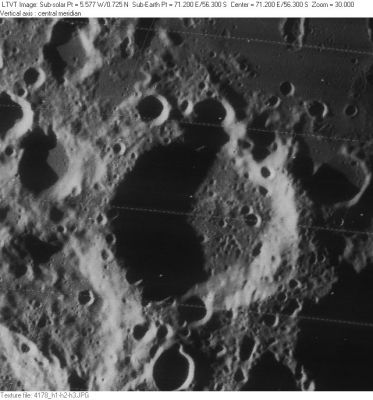
Hanno
Contents
Hanno
|
Lat: 56.3°S, Long: 71.2°E, Diam: 56 km, Depth: 3.32 km, Rükl: 76 |
Images
LPOD Photo Gallery Lunar Orbiter Images Apollo Images
- Hanno as seen by a Hasselblad camera of Apollo 15, and captured on color film: AS15-96-13093. In this photograph, the location of Hanno is a little bit above the central part of the frame's left margin. See also the Hi-Res scan: AS15-96-13093 HR.
- Research: Danny Caes.
Maps
(LAC zone 129D1) USGS Digital Atlas PDF
Description
Description: Elger
(IAU Directions) HANNO.--A smaller and more regular enclosure, adjoining Pontecoulant on the N.E., and still nearer the limb.
Description: Wikipedia
Additional Information
Depth data from Kurt Fisher database
- Westfall, 2000: 3.32 km
- Cherrington, 1969: 2.01 km
Nomenclature
- Hanno the Navigator was a Carthaginian explorer who flourished c. 450 BC. Carthage dispatched Hanno at the head of a fleet of sixty ships to explore and colonize the west coast of Africa. He sailed through the straits of Gibraltar, founded or repopulated seven colonies along the African coast of Morocco, and explored significantly further along the Atlantic coast of the continent. He encountered various peoples on his journey and met with a variety of welcomes.
- This name formerly referred to a different crater (NASA SP-241, p. 537).
LROC Articles
Bouldery crater near Mare Australe (the tiny high-albedo ray craterlet north of Hanno B, southeast of Brisbane X, west of Brisbane Y).
Bibliography
