Difference between revisions of "Gaudibert"
| Line 3: | Line 3: | ||
{| class="wiki_table" | {| class="wiki_table" | ||
| colspan="2" | | | colspan="2" | | ||
| − | Lat: 10.9°S, Long: 37.8°E, Diam: 34 km, Depth: 0.62 km, [ | + | Lat: 10.9°S, Long: 37.8°E, Diam: 34 km, Depth: 0.62 km, [[R%C3%BCkl%2047|Rükl: 47]]<br /> |
|- | |- | ||
| | | | ||
| Line 16: | Line 16: | ||
[http://www.lpod.org/coppermine/thumbnails.php?album=search&type=full&search=Gaudibert LPOD Photo Gallery] [http://www.lpi.usra.edu/resources/lunar_orbiter/bin/srch_nam.shtml?Gaudibert%7C0 Lunar Orbiter Images] [http://www.lpi.usra.edu/resources/apollo/search/feature/?feature=Gaudibert Apollo Images]<br /> <br /> | [http://www.lpod.org/coppermine/thumbnails.php?album=search&type=full&search=Gaudibert LPOD Photo Gallery] [http://www.lpi.usra.edu/resources/lunar_orbiter/bin/srch_nam.shtml?Gaudibert%7C0 Lunar Orbiter Images] [http://www.lpi.usra.edu/resources/apollo/search/feature/?feature=Gaudibert Apollo Images]<br /> <br /> | ||
==Maps== | ==Maps== | ||
| − | ''([ | + | ''([[LAC%20zone|LAC zone]] 79D2)'' [http://www.lpi.usra.edu/resources/mapcatalog/LAC/lac79/ LAC map] [http://www.lpi.usra.edu/resources/mapcatalog/usgs/I714/ Geologic map] [http://www.lpi.usra.edu/resources/mapcatalog/LTO/lto79d2_1/ LTO map]<br /> <br /> |
==Description== | ==Description== | ||
<br /> | <br /> | ||
| Line 22: | Line 22: | ||
[http://en.wikipedia.org/wiki/Gaudibert_(crater) Gaudibert]<br /> <br /> | [http://en.wikipedia.org/wiki/Gaudibert_(crater) Gaudibert]<br /> <br /> | ||
==Additional Information== | ==Additional Information== | ||
| − | * Depth data from [ | + | * Depth data from [[Kurt%20Fisher%20crater%20depths|Kurt Fisher database]] |
** Westfall, 2000: 0.62 km | ** Westfall, 2000: 0.62 km | ||
** Viscardy, 1985: 1.6 km | ** Viscardy, 1985: 1.6 km | ||
** Cherrington, 1969: 1.58 km | ** Cherrington, 1969: 1.58 km | ||
* Central peak height: | * Central peak height: | ||
| − | ** [ | + | ** [[Sekiguchi%2C%201972|Sekiguchi, 1972]]: |
*** western hill: 2.5 km | *** western hill: 2.5 km | ||
*** eastern hill: 2.0 km <span class="membersnap">- [http://www.wikispaces.com/user/view/fatastronomer [[Image:fatastronomer-lg.jpg|16px|fatastronomer]]] [http://www.wikispaces.com/user/view/fatastronomer fatastronomer]</span> | *** eastern hill: 2.0 km <span class="membersnap">- [http://www.wikispaces.com/user/view/fatastronomer [[Image:fatastronomer-lg.jpg|16px|fatastronomer]]] [http://www.wikispaces.com/user/view/fatastronomer fatastronomer]</span> | ||
| Line 35: | Line 35: | ||
* Named for [http://en.wikipedia.org/wiki/Casimir_Marie_Gaudibert Casimir Marie Gaudibert] (1823-1901), a French astronomer. | * Named for [http://en.wikipedia.org/wiki/Casimir_Marie_Gaudibert Casimir Marie Gaudibert] (1823-1901), a French astronomer. | ||
| − | * According to ''[ | + | * According to ''[[Whitaker|Whitaker]]'' (p. 226), this name was introduced by [[Krieger|Krieger]] and [[K%C3%B6nig|König]]. |
| − | * In 1887, Gaudibert, under the direction of Camille [ | + | * In 1887, Gaudibert, under the direction of Camille [[Flammarion|Flammarion]] (and with Léon Fenet doing the art work), published a lunar map in which they introduced six names later adopted into the original [[IAU%20nomenclature|IAU nomenclature]]: [[Carpenter|Carpenter]], [[Flammarion|Flammarion]], [[Henry%20Fr%C3%A8res|Frères Henry]] (meaning since changed), [[Mouchez|Mouchez]], [[Nasmyth|Nasmyth]] and [[Rutherfurd|Rutherfurd]] ([[Whitaker|Whitaker]], p. 150). A small reproduction of the map appears on p. 149 of Whitaker's book. <span class="membersnap">- [http://www.wikispaces.com/user/view/JimMosher [[Image:JimMosher-lg.jpg|16px|JimMosher]]] [http://www.wikispaces.com/user/view/JimMosher JimMosher]</span> |
<br /> | <br /> | ||
==Lettered Craters== | ==Lettered Craters== | ||
Revision as of 15:49, 15 April 2018
Contents
Gaudibert
|
Lat: 10.9°S, Long: 37.8°E, Diam: 34 km, Depth: 0.62 km, Rükl: 47 | |
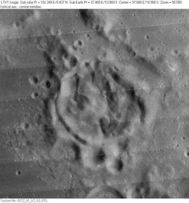
Right: LO-IV-072H Gaudibert is the oddly-shaped crater in the center. The 9-km crater touching its rim at 6 o’clock is Gaudibert C. Below that, the north rim of 21-km Gaudibert A is visible along the bottom margin.
Table of Contents
[#Gaudibert Gaudibert]
[#Gaudibert-Images Images]
[#Gaudibert-Maps Maps]
[#Gaudibert-Description Description]
[#Gaudibert-Description: Wikipedia Description: Wikipedia]
[#Gaudibert-Additional Information Additional Information]
[#Gaudibert-Nomenclature Nomenclature]
[#Gaudibert-Lettered Craters Lettered Craters]
[#Gaudibert-LPOD Articles LPOD Articles]
[#Gaudibert-Bibliography Bibliography]
[#Gaudibert-C. Gaudibert in the Sourcebook Project: C. Gaudibert in the Sourcebook Project:]
Images
LPOD Photo Gallery Lunar Orbiter Images Apollo Images
Maps
(LAC zone 79D2) LAC map Geologic map LTO map
Description
Description: Wikipedia
Additional Information
- Depth data from Kurt Fisher database
- Westfall, 2000: 0.62 km
- Viscardy, 1985: 1.6 km
- Cherrington, 1969: 1.58 km
- Central peak height:
- Sekiguchi, 1972:
- western hill: 2.5 km
- eastern hill: 2.0 km - fatastronomer fatastronomer
- Sekiguchi, 1972:
- Mysterious Gaudibert Crater - Some information on the morphology of Gaudibert as featured in 'Image of the Week' (02/24/2009) from the Apollo Image Archive.
Nomenclature
- Named for Casimir Marie Gaudibert (1823-1901), a French astronomer.
- According to Whitaker (p. 226), this name was introduced by Krieger and König.
- In 1887, Gaudibert, under the direction of Camille Flammarion (and with Léon Fenet doing the art work), published a lunar map in which they introduced six names later adopted into the original IAU nomenclature: Carpenter, Flammarion, Frères Henry (meaning since changed), Mouchez, Nasmyth and Rutherfurd (Whitaker, p. 150). A small reproduction of the map appears on p. 149 of Whitaker's book. - JimMosher JimMosher
Lettered Craters


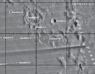
Left: Excerpt from the USGS Digital Atlas of the Moon - LAC 79.
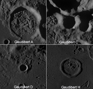
Right: WAC view (M117249908ME) of the lettered craters. Click image for larger view.
LPOD Articles
A Crater of Multiple Strangeness
Bibliography
Hawke, B. A. et al (1997) Remote Sensing Studies of Geologic Units in the Eastern Nectaris Region of the Moon - from the 28th Lunar And Planetary Institute Conference 1997.
C. Gaudibert in the Sourcebook Project:
- Curious Lunar Formation (English Mechanic, 1874), see: Mysterious Universe, a handbook of astronomical anomalies (William R. Corliss, The Sourcebook Project, 1979).
This page has been edited 1 times. The last modification was made by - tychocrater tychocrater on Jun 13, 2009 3:24 pm - afx3u2

