Cape Banat
Contents
Cape Banat
(discontinued IAU name)|
Lat: 17.4°N, Long: 17.4°W, Diameter: km, Depth: 1.8 km, Rükl: 20 |

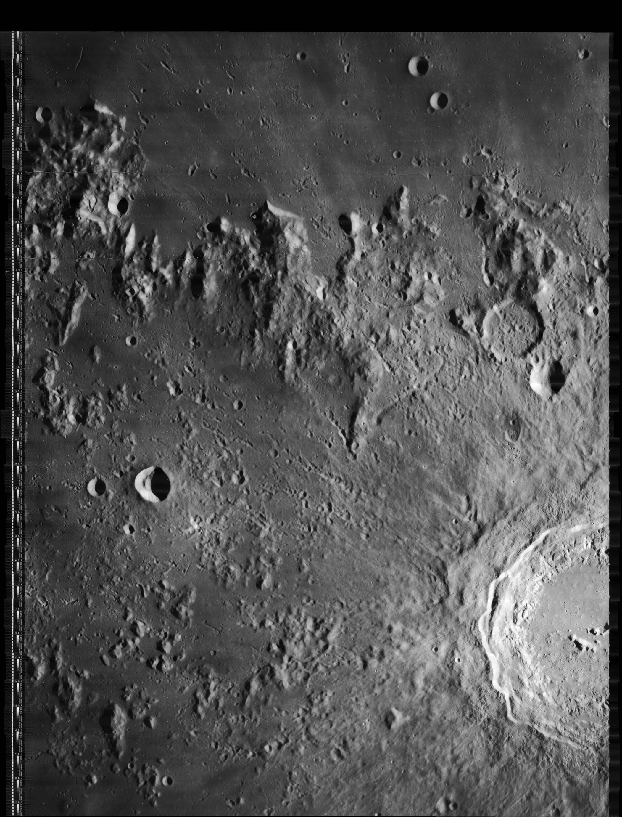
Cape Banat at centre of frame. The large crater straddling the margin at the lower left is T. Mayer, with T. Mayer A to its right. The cape extends diagonally up from this, ending in the pyramid-shaped peak at its tip. Note the peculiar snake like depression north of Cape Banat, which is a good test object for common amateur telescopes.
Images
LPOD|Photo Gallery images Lunar Orbiter Images
Cape Banat on Lunar Orbiter IV photographs (Hi-Res scans)
LOIV-126-h2 (Cape Banat near the frame's upper left corner)
LOIV-133-h2 (Cape Banat near the frame's upper right corner)
Cape Banat on orbital photographs made during the mission of Apollo 17
- Apollo 17's series of south looking oblique Fairchild-camera views of Mare Imbrium's southern part and adjacent Montes Carpatus show the incorporated Cape Banat slightly "to the left" of centre in frames AS17-M-2447, AS17-M-2448, and AS17-M-2449. It is interesting to know that these photographs could be used to create three-dimensional images when they are rotated 90 degrees to the left or to the right.
  - The most northern part of Cape Banat was captured on few frames made by Apollo 17's panoramic ITEK-camera, of which AS17-P-3098 is perhaps the best one. Note the odd snake-shaped depression slightly north ("to the right") of Cape Banat's northern end. I wonder if it already received an official name.
  - Apollo 17's NIKON-camera photograph AS17-160-23991 shows Cape Banat near the centre of the frame, and Copernicus (aka The Monarch of the Moon) at the central part of the curved horizon.
  - AS17-139-21291 is one of Apollo 17's Hasselblad-camera photographs of Cape Banat.

  Additional research Lunar Orbiter IV and Apollo 17 photography: Danny Caes
Maps
(LAC zone 40D4) LAC map Geologic map
Description
This once-named protrusion of the Carpathian Mountains into the southern part of Mare Imbrium is no longer part of the IAU Nomenclature.
Additional Information
- Judging from the shadows, the pyramid-shaped peak at the tip of the promontory rises about 1,800 m above the floor of Mare Imbrium. - Jim Mosher
Nomenclature
- Named for the Banat region of the terrestrial Carpathians.
- This name was introduced as “Kap Banat” by Krieger and König, who also had named features called “Banat” and “Banat Sinus”. The first of these, only, was accepted as “Cape Banat” in the original IAU nomenclature of 1935 as prepared by Blagg and Müller. The name was deleted by Kuiper et al., whose changes to Blagg and Müller (published in the Photographic Lunar Atlas) were approved by the IAU in 1961. (Whitaker, p. 226).
- Also called Promontorium Banat on certain maps and atlases. It is called K. Banaat (Kaap Banaat) on Section IV of the greenish colored map in A.J.M. Wanders's book Op Ontdekking in het Maanland (Het Spectrum, 1949).- DannyCaes Oct 21, 2012
- Banat's snake, a peculiar snake-shaped depression just north of Promontorium Banat, thus nicknamed by Danny Caes http://bit.ly/2zjp8LC
LPOD Articles
Bibliography
For explorers and investigators of books about the distinct major wave of observations of strange objects above the Banat region in the terrestrial Carpathians, I recommend the very interesting books from Flemish author Julien Weverbergh and Romanian author Ion Hobana (especially the book Ufo's in Oost en West, deel 2: Ufo's boven het oostblok).
 - DannyCaes Sep 13, 2016 (yes, it's an UFO book, but... neat and seriously written UFO books from serious authors are never boring!!!).