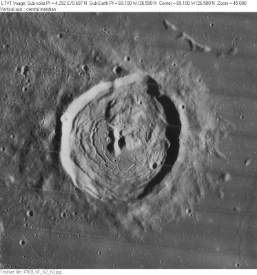
Briggs
Contents
Briggs
|
Lat: 26.5°N, Long: 69.1°W, Diam: 37 km, Depth: 1.2 km, Rükl: 17 |
Images
LPOD Photo Gallery Lunar Orbiter Images Apollo Images
- According to Apollo 15's Fairchild-metric mapping frames, crater Briggs was the Apollo project's most westerly sunlit surface formation which could be observed and photographed while in orbit (other more westerly surface formations, also photographed during the Apollo project, were earthlit).
- Of Apollo 15's oblique southward looking Fairchild camera frames of REV 71, frames AS15-M-2621 and AS15-M-2622 also show the eastern illuminated part of Briggs. The caption "Eddington" in frame 2622 is an error!
- Research orbital Apollo photography: Danny Caes
Maps
(LAC zone 38A4) : LAC map Geologic map LM map
Description
Description: Elger
(IAU Directions) BRIGGS.--This bright regular ring-plain, 33 miles in diameter, is situated a short distance N. of Otto Struve A. A long ridge traverses the interior from N. to S. On the W. is another large enclosure, communicating with Otto Struve on the S., and really forming a N. extension of this formation. It has a large and very deep crater, 12 miles in diameter, on its E. border.
Description: Wikipedia
Additional Information
- Depth data from Kurt Fisher database
- Pike, 1976: 1.2 km
- Westfall, 2000: 1.2 km
- Viscardy, 1985: 1.16 km
- Cherrington, 1969: 1.15 km
- Central peak height
- Sekiguchi, 1972: 0.2 km, 0.1 km "These two objects are generally regarded as one mountain block and named as [beta]" - fatastronomer
- The shadows cast by the east wall in LO-IV-169H are consistent with the many estimates of this crater's depth, including the 1,150 m given on LM-38. But the central peaks are a bit taller than the 400 m, or so, suggested by the contours on LM-38: the shadows from the southwest peak indicates a height of about 630 m; and the broader peak to its west is at least as tall, since it has an equally long shadow without even reaching the floor. The shadow cast to the outside by the west wall corresponds to a rim height of a little over 500 m, but the total rim height must be greater since this shadow does not reach fully down to the surrounding terrain. - JimMosher
- The “large enclosure” that Elger describes to the west of Briggs, with the “large and very deep crater ... on its E. border”, is the one now known as Russell.
- Satellite crater Briggs B is on the ALPO list of bright ray craters.
- Central peak height - Briggs B
- Wood, 1971: 0.42 km - tychocrater Mar 17, 2008
- Sekiguchi, 1972: 0.3 km - fatastronomer
- TSI = 20, CPI = 20, FI = 25; MI =65 Smith and Sanchez, 1973
Nomenclature
- Named for Henry Briggs (February 1561–January 26, 1630), an English mathematician notable for changing Napier's logarithms into common/Briggesian logarithms and was the man most responsible for scientists' acceptance of logarithms.
- According to Whitaker (p. 218) this name was introduced by Schröter, although the name Briggi (p. 195) had been used earlier by Van Langren for the crater we now call Curtius B.
- Briggs Eta (hillock northwest of Briggs B), Briggs Xi (hillock southeast of Briggs C) (see chart SLC F3) (System of Lunar Craters, 1966).
- Rimae Briggs (a dedicated rille seeker's unofficial name for the system of rilles on the floor of Briggs).
LPOD Articles
Bibliography
- Briggs: Biodgraphy on the MacTutor History of Mathematics archive.
