Büsching
Contents
Büsching
|
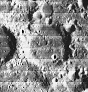
Lat: 38.0°S, Long: 20.0°E, Diam: 52 km, Depth: 1.81 km, Rükl: 66 |
Table of Contents
[#Büsching Büsching]
[#Büsching-Images Images]
[#Büsching-Maps Maps]
[#Büsching-Description Description]
[#Büsching-Description: Elger Description: Elger]
[#Büsching-Description: Wikipedia Description: Wikipedia]
[#Büsching-Additional Information Additional Information]
[#Büsching-Nomenclature Nomenclature]
[#Büsching-LPOD Articles LPOD Articles]
[#Büsching-Bibliography Bibliography]

LOIV 095 H2
Images
LPOD Photo Gallery Lunar Orbiter Images Apollo Images
Maps
(LAC zone 113A3) LAC map Geologic map
Description
Description: Elger
(IAU Directions) BUSCHING.--A ring-plain S. of Zagut, about 36 miles in diameter, with a moderately high but irregular wall. There are several craterlets within and some low hills.
Description: Wikipedia
Additional Information
Depth data from Kurt Fisher database
- Westfall, 2000: 1.81 km
- Viscardy, 1985: 1.7 km
- Cherrington, 1969: 2.4 km
- Satellite crater Busching E is on the ALPO list of banded craters
Nomenclature
Anton Friedrich Büsching (1724-1793) was a celebrated German geographer. His Erdbeschreibung ("Earth description") was the first geographical work of any scientific merit. It gives only the geography of Europe.
LPOD Articles
Bibliography
This page has been edited 1 times. The last modification was made by - tychocrater tychocrater on Jun 13, 2009 3:24 pm - afx3u2