Elbow
Contents
Elbow (Apollo 15 site craterlet name)
|
Lat: 26.0°N, Long: 3.6°E, Diam: 0 km, Depth: km, Rükl: 22 |
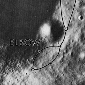
Apollo 15 Site Traverses Chart The dark area in the upper left is the shadowed wall of Rima Hadley, on whose east rim this crater lies.
Images
LPOD Photo Gallery Lunar Orbiter Images Apollo Images
- According to page 105 of David M. Harland's book Exploring the Moon; the Apollo expeditions, B&W Hasselblad photograph AS15-85-11415 shows the barely distinguishable crater Elbow, with the western part of Rima Hadley in the distance, and Bennett Hill at the horizon.
- Preceding photographs AS15-85-11414 and AS15-85-11413 show the eastern parts of Elbow, and also the aft part of the Lunar Roving Vehicle (LRV).
- Additional research Apollo 15 photography: Danny Caes
Maps
(LAC zone 41B4) LAC map Geologic map LM map LTO map
Description
The Landing Site Name "Elbow" is plotted on Topophotomap 41B4/S1 .
Description: Wikipedia
Elbow (correct link)
Additional Information
Nomenclature
Astronaut-named feature, Apollo 15 site.
LPOD Articles
Bibliography
Kenneth F. Weaver: Apollo 15 explores the mountains of the moon (National Geographic, February 1972).
  David M. Harland: EXPLORING THE MOON; The Apollo Expeditions.
  Eric M. Jones: APOLLO LUNAR SURFACE JOURNAL (ALSJ).
