Rükl 25
Contents
Rükl Zone 25 - ROMER
Neighboring maps on the Rükl Nearside Map:
Table of Contents
[#Rükl Zone 25 - ROMER Rükl Zone 25 - ROMER]
[#Rükl Zone 25 - ROMER-Photographic Map Photographic Map]
[#Rükl Zone 25 - ROMER-Named Features Named Features]
[#Rükl Zone 25 - ROMER-Additional IAU-named features associated with the Apollo 17 Site Additional IAU-named features associated with the Apollo 17 Site]
[#Rükl Zone 25 - ROMER-Luna 21 and Lunokhod 2 Luna 21 and Lunokhod 2]
[#Rükl Zone 25 - ROMER-Lettered Crater Locations Lettered Crater Locations]
[#Rükl Zone 25 - ROMER-Additional Information Additional Information]
| 25 |
||
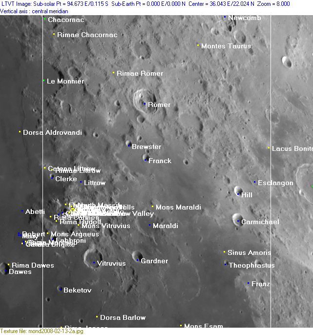
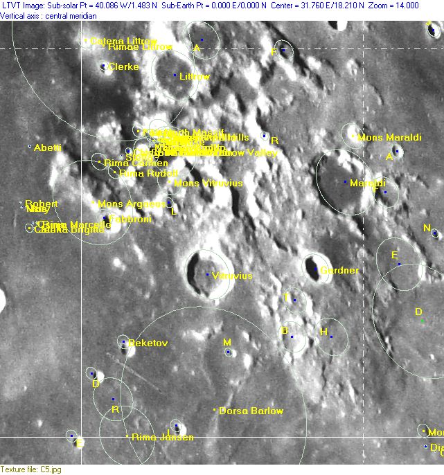
Photographic Map
(This map is based on an Earth-based photograph that has been computer-corrected to zero libration. The vertical white lines indicate the left and right boundaries of the Rükl rectangle)

  Background image source
Named Features
- Apollo 17 (sixth manned landing on the moon, Apollo 17's LM Challenger soft-landed on December 11, 1972, at the Taurus-Littrow Valley).
- Apollo 17 ascent stage of LM Challenger (seems to have impacted at 19.96° North/ 30.50° East, on one of the slopes of the South Massif, alas, out of sight of the television camera on Apollo 17's Lunar Roving Vehicle (LRV) at the Taurus-Littrow Valley).
- (who knows, perhaps in the year 2017 there will be a small unmanned four-wheeled rover from AUDI at the Taurus-Littrow Valley, crawling its way toward "Challenger's Baby") (the Lunar Roving Vehicle of Apollo 17).
- Ataturk (a disallowed name from H.P.Wilkins for Romer A, north-northeast of Romer itself) (Romer A was also called Stephanides by F.C.Lamech).
- Beketov
- Bernini (a disallowed name for the bowl shaped crater Jansen L near Rima Jansen, see Lunar Topographic Orthophotomap 61-A1).
- Brewster
- Carmichael (Van Langren's Brunii).
- Catena Le Monnier (an unofficial name from D.Caes for the row of tiny depressions on the floor of Le Monnier).
- Catena Littrow
- Chacornac
- Ching-Te
- Clerke
- Dorsa Barlow
- Esclangon
- Evans (an unofficial name from D.Caes for one of the officially unnamed craterlets near the landingsite of Apollo 17 at the Taurus-Littrow valley) (Ronald Evans, 1933-1990, Command Module Pilot of Apollo 17).
- Fabbroni
- Fat Eight (a nickname from D.Caes for the curious "8" shaped formation about halfway between Beketov and Vitruvius).
- Fisher (a disallowed name from H.P.Wilkins for Vitruvius B, southeast of Vitruvius itself).
- Franck
- Franz
- Gardner
- Gardner Megadome (south of Gardner, unofficial name).
- Hill
- Jansen R's small companion (a nickname from D.Caes for the officially unnamed ghost-crater southeast of the much larger ghost-crater Jansen R), see http://bit.ly/2wtwbzB
- Lacus Bonitatis (J.Hewelcke's Paludes Cimmeriae).
- Lacus Locusta', or: Lobster Lake (lunar observer Ronb(ee)s nickname for a lobster-like area near Lacus Bonitatis) (could also be on Chart 26, I have to check this out, - DannyCaes DannyCaes Nov 12, 2015).
- Le Monnier
- Littrow
- Luna 21 (soft-landed on January 15, 1973, at the southern part of Le Monnier's floor) (Luna 21 delivered mankind's second unmanned 8-wheeled crawler, known as Lunokhod 2) (after Luna 17 with its Lunokhod 1 south of Promontorium Heraclides).
- Maraldi
- Mons Argaeus
- Mons Esam
- Mons Maraldi
- Mons Vitruvius (of which the northern part was called East Massif during the mission of Apollo 17 in december 1972).
- Montes Taurus (J.Hewelcke's Taurica Chersonnesus).
- Newcomb (Van Langren's Boivinii, J.Hewelcke's Mons Trapezus).
- Prom. Arietis (J.Hewelcke's disallowed name for a certain area near Vitruvius).
- Rima Carmen
- Rima Jansen (near the lower left corner of Chart 25).
- Rima Rudolf (once called Fossa Rudolf, see Lunar Topophotomap 42C3S3).
- Rimae Chacornac (once known as Fossa (or Fossae?) Chacornac, see Lunar Topographic Orthophotomap 43-A4).
- Rimae Littrow (once known as Fossae Littrow, see Lunar Topographic Orthophotomaps 42-C2, 43-A4, 43-D1).
- Rimae Römer (once known as Fossa (or Fossae?) Romer, see Lunar Topographic Orthophotomap 43-A4).
- Römer (Van Langren's Cartesii, J.Hewelcke's Mons Berosus).
- Sinus Amoris (Van Langren's Sinus Opticus, J.Hewelcke's Palus Byces).
- Stella
- Stephanides (a disallowed name from F.C.Lamech for Romer A, north-northeast of Romer itself) (Romer A was also called Ataturk by H.P.Wilkins).
- Taurus-Littrow Valley (the landingsite of Apollo 17's LM Challenger, between the North and South Massifs).
- Terra Sapientiae (Van Langren's disallowed name for the region occupying the upper right part of Chart 25).
- Terra Vitae (Riccioli's discontinued name for the region occupying the upper right part of Chart 25).
- Theophrastus
- Vitruvius (Van Langren's Cocci).
Additional IAU-named features associated with the Apollo 17 Site
- Bear Mountain (could be observed through telescope).
- Bowen-Apollo
- Brontë
- Camelot
- Cochise
- Emory
- Falcon
- Family Mountain (could be observed through telescope).
- Hess-Apollo
- Horatio
- Lara
- Light Mantle (could be observed through telescope).
- Mackin
- Nansen-Apollo
- North Massif (could be observed through telescope).
- Powell
- Scarp
- Sculptured Hills (could be observed through telescope).
- Shakespeare
- Sherlock
- Shorty
- South Massif (could be observed through telescope).
- Steno-Apollo
- Taurus-Littrow Valley (it should be mentioned that the largest one of the small craters on the floor of the Taurus-Littrow Valley was once called MOCR (Mission Operations Control Room) during the mission of Apollo 17 in december 1972) (the MOCR is perhaps detectable on High-Resolution webcam images made through powerful telescopes) - DannyCaes DannyCaes Sep 12, 2015
- Tortilla Flat
- Trident
- Van Serg
- Victory
- Wessex Cleft (could be observed through telescope).
Luna 21 and Lunokhod 2
See LPOD Close-Up of a Rille (December 19, 2008).
  Unofficial names along the track of Lunokhod 2:
- Circle harbour
- Far cape
- Fossa Incospicua
- Fossa Recta
- Gentle crater
- Near cape
- Oncoming hills
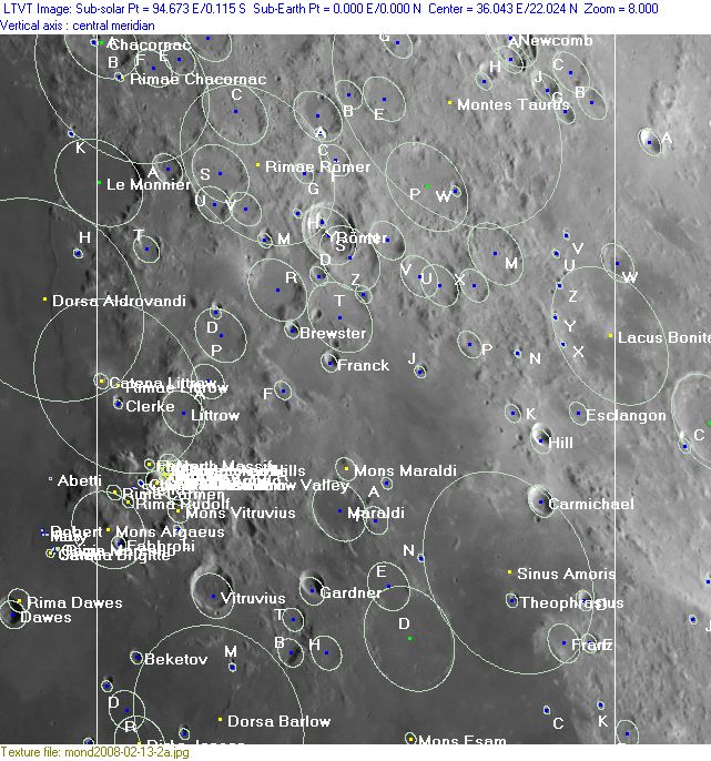
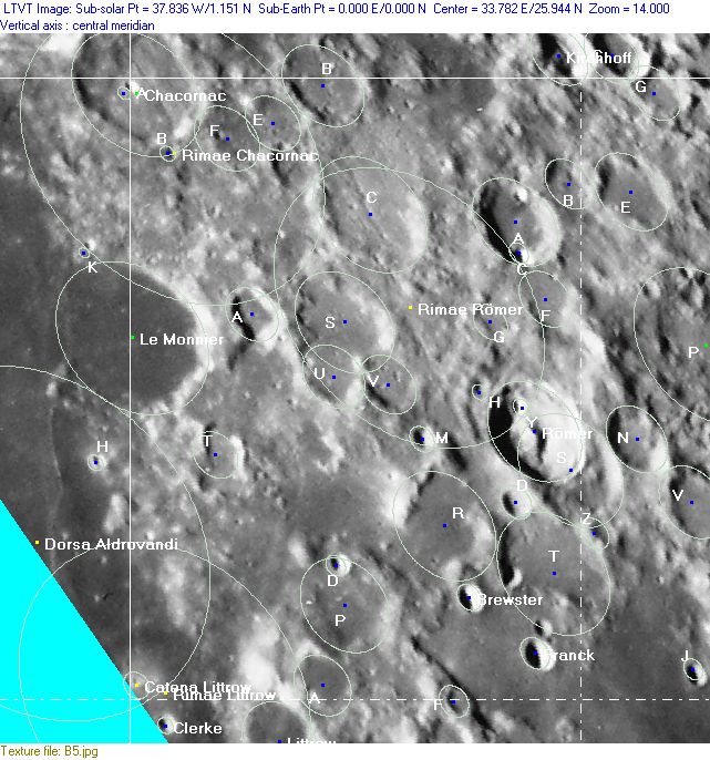
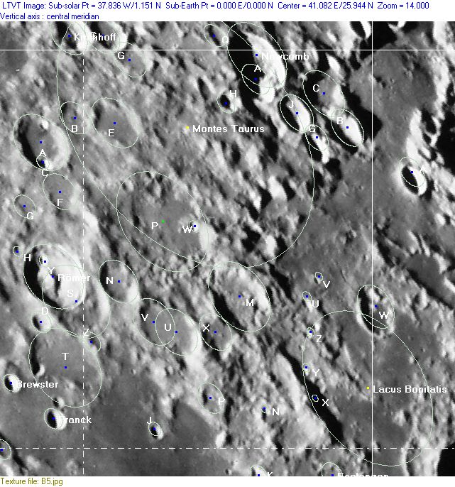
Lettered Crater Locations
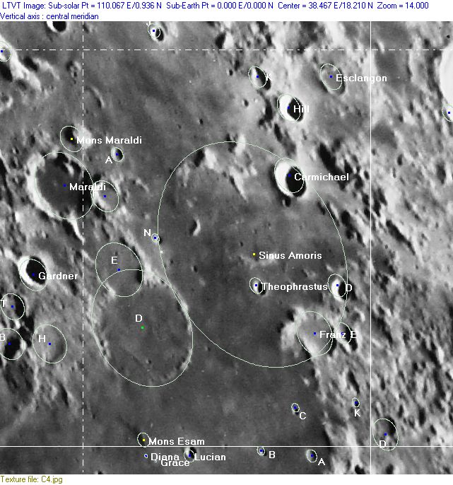
(click on the thumbnails to display full-sized images; use browser BACK button to return - the dashed white lines are the midpoints of the Rükl zones)

  Full zone with lettered craters:


  Lettered craters by quadrants:
| North West |
North East |
| South West |
South East |
Additional Information
- Other online descriptions of features in this Rükl map section:
This page has been edited 1 times. The last modification was made by - tychocrater tychocrater on Jun 13, 2009 3:24 pm - mgx2
