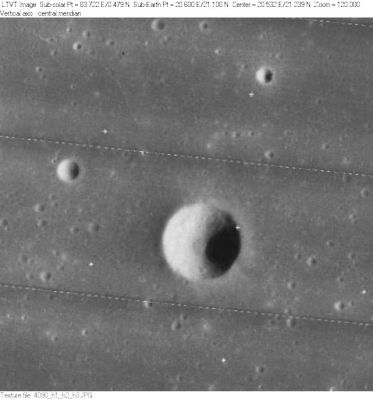
Deseilligny
Contents
Deseilligny
| Lat: 21.1°N, Long: 20.6°E, Diam: 6 km, Depth: 1.344 km, Rükl: 24 |
Table of Contents

LO-IV-090H
Images
LPOD|Photo Gallery images Lunar Orbiter Images Apollo Images
"Forgotten" orbital Apollo photographs of Deseilligny (absence of the name Deseilligny in the LPI's scans):
- Oblique southward-looking views of Deseilligny are seen in Apollo 15's orbital ITEK-panoramic frames AS15-P-9320 and AS15-P-9325. Deseilligny is the pronounced bowl-shaped crater near the left margins of both frames.
- Oblique northward-looking views of Deseilligny: ITEK-frames AS15-P-9894 and 9899 (on both frames, scroll toward the right margins).
- Post sunrise views of Deseilligny: Apollo 17's ITEK-frames AS17-P-2337 and 2342 (scroll rightward beyond the centres of both frames).
Research: Danny Caes
Maps
(LAC zone 42C1) LAC map Geologic map LM map LTO map
Description
Description: Wikipedia
Additional Information
Depth data from Kurt Fisher database
- Elachi, 1976: 1.344 km
- Pike, 1976: 1.25 km
- Arthur, 1974: 1.19 km
- Westfall, 2000: 1.25 km
- Viscardy, 1985: 1.19 km
- The shadows in LO-IV-090H indicate Deseilligny is about 1230 m deep. - JimMosher JimMosher
- Thermal anomaly crater, implying youthful age - Moore et al, 1980
Nomenclature
- Jules Alfred Pierrot Deseilligny; French selenographer (1868-1918).
- Named by Lamech (Whitaker, p 228).
LPOD Articles
Bibliography
This page has been edited 1 times. The last modification was made by - tychocrater tychocrater on Jun 13, 2009 3:24 pm - afx3