Becvar
Contents
Becvár
| Lat: 1.9°S, Long: 125.2°E, Diam: 67 km, Depth: km, Rükl: (farside) |
Table of Contents
[#Becvár Becvár]
[#Becvár-Images Images]
[#Becvár-Maps Maps]
[#Becvár-Description Description]
[#Becvár-Description: Wikipedia Description: Wikipedia]
[#Becvár-Additional Information Additional Information]
[#Becvár-Nomenclature Nomenclature]
[#Becvár-LPOD Articles LPOD Articles]
[#Becvár-Bibliography Bibliography]

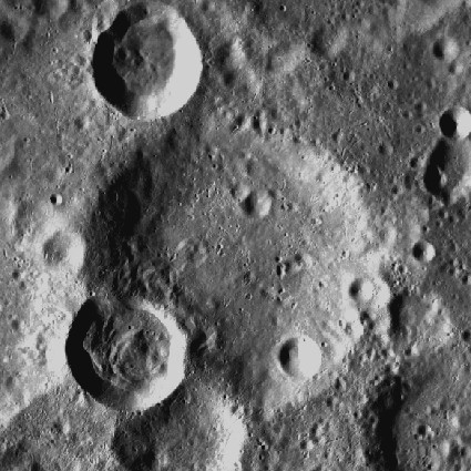
LROC . Becvár is the eroded crater at center, satellites X and Q at left. This crater lies on bright terrain from nearby Necho ejecta field.
Images
LPOD Photo Gallery Lunar Orbiter Images Apollo Images
- WARNING: one of Apollo 14's photographs (AS14-75-10308) seems to show a crater called "BELVAR" (which should be Becvar, of course).- DannyCaes DannyCaes Oct 22, 2013
- AS17-147-22453 shows Apollo 17's CSM America above Becvar X', a crater which is located just north-northwest of Becvar itself. The dark "triangle" in the lower right corner is the silhouette of LM Challengers window-margin. Note: this orbital photograph is the first in a series which shows the rotation of CSM America. The last photographs in this series show the interior of the Service Module's SPS-bell (Service Propulsion System). These are VERY interesting photographs!
- AS10-28-4013 shows an oblique look at Becvar Q, which is the crater touching the southwestern part of Becvar's rim.
- Becvar itself was also captured on Apollo 16's panoramic ITEK-camera frame AS16-P-5520, made while in Trans Earth Coast (TEC). Becvar is noticeable near the terminator. It seems to be the centre of a much larger crater.
- Research orbital Apollo photography: Danny Caes
Maps
(LAC zone 83B2) USGS Digital Atlas PDF
IAU page: Becvár
Description
Description: Wikipedia
Additional Information
Nomenclature
- Named for Antonín Becvár (1901-1965), a Czechoslovakian astronomer best known for his star atlas.
- Becvár entered the IAU nomenclature in the long list of farside names published in Menzel, 1971.
- The current IAU-approved spelling of this name contains an accented characters that cannot be represented in Wiki text. Visit the IAU Gazetteer page for the proper representation of this name.
- Somewhere in this region, near Becvar, or south of it (between King and Tsiolkovskiy), should be a surface formation which was once called "S.A.R." or "SAR". This abbrevation is mentioned in the Apollo 16 Preliminary Science Report, Page 29-63 (Figure 29-82). (detected by D. Caes). What was the meaning of "S.A.R."?
LPOD Articles
Bibliography
This page has been edited 1 times. The last modification was made by - tychocrater tychocrater on Jun 13, 2009 3:24 pm - afx3u2