Difference between revisions of "Andel"
| Line 6: | Line 6: | ||
|} | |} | ||
<div id="toc"> | <div id="toc"> | ||
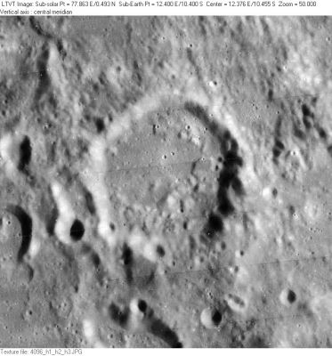
| − | [http://www.lpod.org/coppermine/albums/userpics/Andel_LO-IV-096H_LTVT.JPG [[Image: | + | [http://www.lpod.org/coppermine/albums/userpics/Andel_LO-IV-096H_LTVT.JPG [[Image:Normal_Andel_LO-IV-096H_LTVT.JPG|external image normal_Andel_LO-IV-096H_LTVT.JPG]]]<br /> ''[http://lpod.org/coppermine/displayimage.php?pos=-2702 LO-IV-096H]'' A number of [[satellite%20feature|lettered craters]] associated with '''Andel''' are visible in this view. Part of the ancient 27-km diameter '''Andel M''' is visible in the upper left corner, below that is 8-km '''Andel N''', and below that the eastern half of 14-km '''Andel A'''.<br /> <br /> |
==Images== | ==Images== | ||
[http://www.lpod.org/coppermine/thumbnails.php?album=search&type=full&search=Andel LPOD Photo Gallery] [http://www.lpi.usra.edu/resources/lunar_orbiter/bin/srch_nam.shtml?Andel%7C0 Lunar Orbiter Images] [http://www.lpi.usra.edu/resources/apollo/search/feature/?feature=Andel Apollo Images]<br /> <br /> | [http://www.lpod.org/coppermine/thumbnails.php?album=search&type=full&search=Andel LPOD Photo Gallery] [http://www.lpi.usra.edu/resources/lunar_orbiter/bin/srch_nam.shtml?Andel%7C0 Lunar Orbiter Images] [http://www.lpi.usra.edu/resources/apollo/search/feature/?feature=Andel Apollo Images]<br /> <br /> | ||
| Line 18: | Line 18: | ||
* The depth given in the title line is the maximum depth read from [http://www.lpi.usra.edu/resources/mapcatalog/LTO/lto78d1_1/ LTO-78D1]. The LTO shows '''Andel''' has a relatively flat floor at an elevation of about 7800 m and a rim ranging in height from 8700 to 9770 m (a constant offset of 1,730,000 m has to be added to all these numbers to obtain radial distances from the Moon's center). According to the LTO, the southern part of '''Andel''''s rim, which under the lighting of the [http://www.lpi.usra.edu/resources/lunarorbiter/frame/?4096 Lunar Orbiter photo] looks nearly non-existent, has a substantial height of about 9200 m (1400 m above the floor). <span class="membersnap">- Jim Mosher</span> | * The depth given in the title line is the maximum depth read from [http://www.lpi.usra.edu/resources/mapcatalog/LTO/lto78d1_1/ LTO-78D1]. The LTO shows '''Andel''' has a relatively flat floor at an elevation of about 7800 m and a rim ranging in height from 8700 to 9770 m (a constant offset of 1,730,000 m has to be added to all these numbers to obtain radial distances from the Moon's center). According to the LTO, the southern part of '''Andel''''s rim, which under the lighting of the [http://www.lpi.usra.edu/resources/lunarorbiter/frame/?4096 Lunar Orbiter photo] looks nearly non-existent, has a substantial height of about 9200 m (1400 m above the floor). <span class="membersnap">- Jim Mosher</span> | ||
* The shadows in [http://www.lpi.usra.edu/resources/lunarorbiter/frame/?4096 LO-IV-096H] indicate a depth of at least 1600 m. <span class="membersnap">- Jim Mosher</span> | * The shadows in [http://www.lpi.usra.edu/resources/lunarorbiter/frame/?4096 LO-IV-096H] indicate a depth of at least 1600 m. <span class="membersnap">- Jim Mosher</span> | ||
| − | * According to [[Sekiguchi%2C%201972|Sekiguchi, 1972]], '''Andel A''' has a central peak that is 0.4km tall and an additional small hill that is 0.3km tall. <span class="membersnap">- [http://www.wikispaces.com/user/view/fatastronomer [[Image: | + | * According to [[Sekiguchi%2C%201972|Sekiguchi, 1972]], '''Andel A''' has a central peak that is 0.4km tall and an additional small hill that is 0.3km tall. <span class="membersnap">- [http://www.wikispaces.com/user/view/fatastronomer [[Image:Fatastronomer-lg.jpg|16px|fatastronomer]]] [http://www.wikispaces.com/user/view/fatastronomer fatastronomer]</span> These values seem slightly inconsistent with [http://www.lpi.usra.edu/resources/mapcatalog/LTO/lto78d1_1/ LTO-78D1], which shows maximum height variations of about 200 m, but the [[LTO|LTO]]'s are not infallible. The features measured by Sekiguchi are just outside the left margin of the image shown above. <span class="membersnap">- Jim Mosher</span> |
<br /> | <br /> | ||
==Nomenclature== | ==Nomenclature== | ||
Revision as of 18:43, 15 April 2018
Contents
Andel
|
Lat: 10.4°S, Long: 12.4°E, Diam: 35 km, Depth: 2.0 km, Rükl: 45 |
LO-IV-096H A number of lettered craters associated with Andel are visible in this view. Part of the ancient 27-km diameter Andel M is visible in the upper left corner, below that is 8-km Andel N, and below that the eastern half of 14-km Andel A.
Images
LPOD Photo Gallery Lunar Orbiter Images Apollo Images
Maps
(LAC zone 78D1) LAC map Geologic map LM map LTO map
Description
Description: Wikipedia
Additional Information
- The depth given in the title line is the maximum depth read from LTO-78D1. The LTO shows Andel has a relatively flat floor at an elevation of about 7800 m and a rim ranging in height from 8700 to 9770 m (a constant offset of 1,730,000 m has to be added to all these numbers to obtain radial distances from the Moon's center). According to the LTO, the southern part of Andel's rim, which under the lighting of the Lunar Orbiter photo looks nearly non-existent, has a substantial height of about 9200 m (1400 m above the floor). - Jim Mosher
- The shadows in LO-IV-096H indicate a depth of at least 1600 m. - Jim Mosher
- According to Sekiguchi, 1972, Andel A has a central peak that is 0.4km tall and an additional small hill that is 0.3km tall. - fatastronomer fatastronomer These values seem slightly inconsistent with LTO-78D1, which shows maximum height variations of about 200 m, but the LTO's are not infallible. The features measured by Sekiguchi are just outside the left margin of the image shown above. - Jim Mosher
Nomenclature
- Karel Andel (1884-1948); Czechoslovakian astronomer .
- Named by Karl Müller in Named Lunar Formations in 1935 (Whitaker, p 229).
- Andel is one of the relatively few people to have a crater named after them while they were still alive.
- This name contains an accented "e" that cannot be represented in Wiki text. Follow the Wikipedia links or visit the IAU Gazetteer page for the proper representation of this name.
LPOD Articles
Somewhere over the Rainbow (Andel and its environs during local sunset).
Bibliography
