Difference between revisions of "Rimae Littrow"
(Created page with "<div id="content_view" class="wiki" style="display: block"> =Rimae Littrow (I, II, III, IV, V, VI, and VII)= (unofficially known as Fossae Littrow)<br /> {| class="wiki_t...") |
|||
| Line 30: | Line 30: | ||
<br /> | <br /> | ||
==LPOD Articles== | ==LPOD Articles== | ||
| − | [http:// | + | [http://www2.lpod.org/wiki/September_21,_2004 Littrow Rilles - A Wider View][http://www2.lpod.org/wiki/September_20,_2004 Young Fractures]<br /> <br /> |
==Bibliography== | ==Bibliography== | ||
<br /> <br /> | <br /> <br /> | ||
---- | ---- | ||
''afx3u2''</div> | ''afx3u2''</div> | ||
Revision as of 19:28, 11 April 2018
Contents
Rimae Littrow (I, II, III, IV, V, VI, and VII)
(unofficially known as Fossae Littrow)
| Lat: 22.1°N, Long: 29.9°E, Length: 115 km, Depth: km, Rükl: 25 |


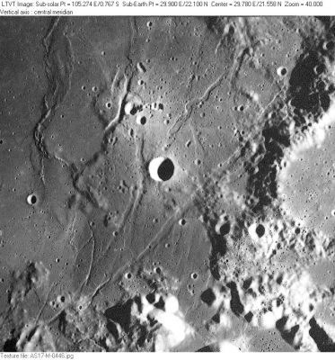
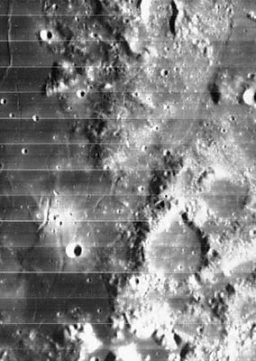
Left: Apollo 17 image; AS17-M-0446 This Apollo 17 Metric Camera view shows the southern part of the Rimae Littrow system. [/Clerke Clerke] is the deeply-shadowed 6-km circular crater in the center, with the much smaller craters of [/Catena%20Littrow Catena Littrow] in the bright area to its north. 30-km [/Littrow Littrow], the namesake of both the rilles and the crater chain, is partially visible along the right margin. The [/Apollo%2017%20Site Apollo 17 Landing Site] is below it, along the bottom right margin. Right: LOIV 078 H3
Table of Contents
[#Rimae Littrow (I, II, III, IV, V, VI, and VII) Rimae Littrow (I, II, III, IV, V, VI, and VII)]
[#Rimae Littrow (I, II, III, IV, V, VI, and VII)-Images Images]
[#Rimae Littrow (I, II, III, IV, V, VI, and VII)-Maps Maps]
[#Rimae Littrow (I, II, III, IV, V, VI, and VII)-Description Description]
[#Rimae Littrow (I, II, III, IV, V, VI, and VII)-Description: Wikipedia Description: Wikipedia]
[#Rimae Littrow (I, II, III, IV, V, VI, and VII)-Additional Information Additional Information]
[#Rimae Littrow (I, II, III, IV, V, VI, and VII)-Nomenclature Nomenclature]
[#Rimae Littrow (I, II, III, IV, V, VI, and VII)-LPOD Articles LPOD Articles]
[#Rimae Littrow (I, II, III, IV, V, VI, and VII)-Bibliography Bibliography]
Images
LPOD Photo Gallery Lunar Orbiter Images Apollo Images
- Lunar Orbiter 5's frames 066, 067, 068, and 069 are four photographs of Clerke and the surrounding Rimae Littrow (up to Dorsa Aldrovandi). - DannyCaes DannyCaes Mar 25, 2008
- Apollo 15's orbital Hasselblad frame AS15-87-11710 shows a close-up of the northern portion of Rimae Littrow- tychocrater tychocrater Dec 16, 2008
Maps
([/LAC%20zone LAC zone] 42C2) LAC map Geologic map LM map LTO map
Description
Description: Wikipedia
Additional Information
- Are the main parts of Rimae Littrow (parts I and II) connected with the main part of Rimae Chacornac? - DannyCaes DannyCaes Nov 3, 2017
Nomenclature
- Named after the nearby crater. ([/Littrow Littrow])
- The original IAU nomenclature of [/Blagg%20and%20M%C3%BCller Blagg and Müller] had only one Roman-numeralled rille named after [/Littrow Littrow].
- Unofficially known as Fossae Littrow, see Lunar Topographic Orthophotomaps 42-C2, 43-A4, 43-D1.
LPOD Articles
Littrow Rilles - A Wider ViewYoung Fractures
Bibliography
afx3u2