Difference between revisions of "Hertzsprung"
(Created page with "<div id="content_view" class="wiki" style="display: block"> =Hertzsprung Basin= ''(unofficial name; IAU crater name: '''Hertzsprung'''; 591 km diam)''<br /> {| class="wiki...") |
|||
| Line 48: | Line 48: | ||
* The impact basin is named after the crater. | * The impact basin is named after the crater. | ||
* '''Hertzsprung''' was among the long list of farside names approved by the IAU in 1970 and published in [/Menzel%2C%201971 Menzel, 1971]. | * '''Hertzsprung''' was among the long list of farside names approved by the IAU in 1970 and published in [/Menzel%2C%201971 Menzel, 1971]. | ||
| − | * In the planning for [/Apollo%20program Apollo 8], the first manned circumlunar mission (1968), this crater (which did not then have an official name) was referred to informally as '''''Gilruth''''' (source: [http:// | + | * In the planning for [/Apollo%20program Apollo 8], the first manned circumlunar mission (1968), this crater (which did not then have an official name) was referred to informally as '''''Gilruth''''' (source: [http://www2.lpod.org/wiki/September_9,_2007 Phil Stooke's LPOD]). |
* The name '''''Wien''''' (N° 156) was proprosed for '''Hertzsprung D''' (a crater southwest of [/Michelson Michelson] in the '''Hertzsprung''' basin) on the ''[/Sternberg%20Lunar%20Nomenclature Complete Map of the Moon]'' (1967/1969) made under the direction of the [/Sternberg%20Institute Sternberg Institute]. '''Hertzsprung''' itself (or possibly just the area enclosed by the innermost ring?) was given the provisional name [/Kibal%27chich Kibal'chich]. That name was later adopted by the [/IAU IAU] for a different crater nearby. Research: Danny Caes. | * The name '''''Wien''''' (N° 156) was proprosed for '''Hertzsprung D''' (a crater southwest of [/Michelson Michelson] in the '''Hertzsprung''' basin) on the ''[/Sternberg%20Lunar%20Nomenclature Complete Map of the Moon]'' (1967/1969) made under the direction of the [/Sternberg%20Institute Sternberg Institute]. '''Hertzsprung''' itself (or possibly just the area enclosed by the innermost ring?) was given the provisional name [/Kibal%27chich Kibal'chich]. That name was later adopted by the [/IAU IAU] for a different crater nearby. Research: Danny Caes. | ||
* Three chain-like formations in and near the basin '''Hertzsprung''' were once called '''''GDL''''' ([/Catena%20Leuschner%20%28GDL%29 Catena Leuschner]), '''''GIRD''''' ([/Catena%20Michelson%20%28GIRD%29 Catena Michelson]), and '''''RNII''''' ([/Catena%20Lucretius%20%28RNII%29 Catena Lucretius]) on the ''[/Sternberg%20Lunar%20Nomenclature Complete Map of the Moon]'' (1967/1969) made under the direction of the [/Sternberg%20Institute Sternberg Institute]. These three chain-like formations are all related to the basin [/Mare%20Orientale Mare Orientale] (southeast of '''Hertzsprung'''). The southern two of the three chains ('''''GIRD''''' and '''''RNII''''') are depicted and named on [http://planetologia.elte.hu/ipcd/full_moon_map_1969_4.jpg this part] of the above mentioned map (at location K-6). Research: Danny Caes | * Three chain-like formations in and near the basin '''Hertzsprung''' were once called '''''GDL''''' ([/Catena%20Leuschner%20%28GDL%29 Catena Leuschner]), '''''GIRD''''' ([/Catena%20Michelson%20%28GIRD%29 Catena Michelson]), and '''''RNII''''' ([/Catena%20Lucretius%20%28RNII%29 Catena Lucretius]) on the ''[/Sternberg%20Lunar%20Nomenclature Complete Map of the Moon]'' (1967/1969) made under the direction of the [/Sternberg%20Institute Sternberg Institute]. These three chain-like formations are all related to the basin [/Mare%20Orientale Mare Orientale] (southeast of '''Hertzsprung'''). The southern two of the three chains ('''''GIRD''''' and '''''RNII''''') are depicted and named on [http://planetologia.elte.hu/ipcd/full_moon_map_1969_4.jpg this part] of the above mentioned map (at location K-6). Research: Danny Caes | ||
| Line 55: | Line 55: | ||
Only the book ''The Farside of the Moon; a Photographic Guide'' from Charles J. Byrne (Springer 2008) knows a certain basin on the farside of the moon called the "'''''Hertzberg Basin'''''"'''.''' See page 147 of that book'''.'''<span class="membersnap">- [http://www.wikispaces.com/user/view/DannyCaes [[Image:DannyCaes-lg.jpg|16px|DannyCaes]]] [http://www.wikispaces.com/user/view/DannyCaes DannyCaes] <small>Dec 9, 2017</small></span><br /> <br /> | Only the book ''The Farside of the Moon; a Photographic Guide'' from Charles J. Byrne (Springer 2008) knows a certain basin on the farside of the moon called the "'''''Hertzberg Basin'''''"'''.''' See page 147 of that book'''.'''<span class="membersnap">- [http://www.wikispaces.com/user/view/DannyCaes [[Image:DannyCaes-lg.jpg|16px|DannyCaes]]] [http://www.wikispaces.com/user/view/DannyCaes DannyCaes] <small>Dec 9, 2017</small></span><br /> <br /> | ||
==LPOD Articles== | ==LPOD Articles== | ||
| − | [http:// | + | [http://www2.lpod.org/wiki/April_26,_2004 Ranger 4 impact]<br /> <br /> |
==LROC Articles== | ==LROC Articles== | ||
[http://lroc.sese.asu.edu/posts/548 Thin Dark Layer] (the rim of an unnamed young ray-craterlet on the southern part of '''Hertzsprung''').<br /> <br /> | [http://lroc.sese.asu.edu/posts/548 Thin Dark Layer] (the rim of an unnamed young ray-craterlet on the southern part of '''Hertzsprung''').<br /> <br /> | ||
Revision as of 19:16, 11 April 2018
Contents
Hertzsprung Basin
(unofficial name; IAU crater name: Hertzsprung; 591 km diam)
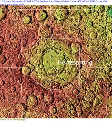
| Lat: 2.6°N, Long: 129.2°W, Main ring diam: 570 km, Basin depth: 4.5-5.3 km, Rükl: (farside) |


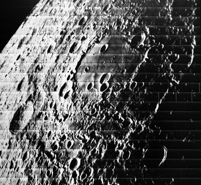
Left: Lunar Orbiter V M26, Middle: Clementine, Clementine LIDAR Altimeter texture from PDS Map-a-Planet remapped to north-up aerial view by LTVT. The dot is the center position and the white circle the main ring position from Chuck Wood's Impact Basin Database. Grid spacing = 10 degrees.
Right: LROC
Table of Contents
[#Hertzsprung Basin Hertzsprung Basin]
[#Hertzsprung Basin-Images Images]
[#Hertzsprung Basin-Maps Maps]
[#Hertzsprung Basin-Basin Classification Basin Classification]
[#Hertzsprung Basin-Description Description]
[#Hertzsprung Basin-Description: Wikipedia Description: Wikipedia]
[#Hertzsprung Basin-Additional Information Additional Information]
[#Hertzsprung Basin-Nomenclature Nomenclature]
[#Hertzsprung Basin-The Hertzberg basin? The Hertzberg basin?]
[#Hertzsprung Basin-LPOD Articles LPOD Articles]
[#Hertzsprung Basin-LROC Articles LROC Articles]
[#Hertzsprung Basin-Bibliography Bibliography]
[#Hertzsprung Basin-Ejnar Hertzsprung in the Sourcebook Project (William R. Corliss) Ejnar Hertzsprung in the Sourcebook Project (William R. Corliss)]
Images
LPOD Photo Gallery Lunar Orbiter Images
- There are no orbital [/Apollo%20program Apollo] photographs of Hertzsprung. During each one of the Apollo missions, this area was in complete darkness (no sunlight, and... no [/Earthshine Earthshine] because Hertzsprung is a farside formation!). The antipodal region of Hertzsprung ([/Mare%20Fecunditatis Mare Fecunditatis]) was always in full sunlight, which is the reason why the antipode of Hertzsprung was one of the most frequently photographed regions on the entire moon! We could call the Hertzsprung part of the moon "Apollo's dark and unphotographed region". Research: Danny Caes
- Hertzsprung's western part is noticeable near the left margin of ZOND 6's photograph of Vavilov, see: Frame 3c. Research: Danny Caes
- Hertzsprung is also depicted in ZOND 6's Frame 4. Hertzsprung's location is a little bit below and to the left of the black cross near the curved limb. Research: Danny Caes
Maps
([/LAC%20zone LAC zone] 71D4) USGS Digital Atlas PDF
[/Lunar%20Basins Basin Classification]
(description of terms and most numeric basin data from Wood, C.A. (2004) Impact Basin Database)
| Certainty of Existence |
USGS Age |
Wilhelms Age Group |
Ring Diameters |
Mare Thickness |
Mascon |
| Certain |
Nectarian |
11 |
150, 255, 380, 570 km |
1.3 km |
Yes, -45 mg gravity anomaly |
Description
This is a multi-ring impact basin with four rings with diameters of 150, 255, 380 and 570 km. It is a Nectarian age mascon basin with a -45 mg anomaly.
Description: Wikipedia
Additional Information
- An alternative depth of 4.5 km and a rim height of 1.06 km were given by Spudis & Adkins, 1996 (LPSC).
- Mg-suite plutons exposed on basin floor: Shearer and Neal.
Nomenclature
- The IAU crater name honors Ejnar Hertzsprung (October 8, 1873, Copenhagen – October 21, 1967, Roskilde), a Danish chemist and astronomer. In the period 1911-1913 with Henry Norris Russell, he developed the Hertzsprung-Russell diagram. In 1913 he determined the distances to several Galactic Cepheid stars by statistical parallax, and was thus able to calibrate the relationship discovered by Henrietta Leavitt between Cepheid period and luminosity. In this determination he made a mistake, possibly a slip of the pen, putting the stars 10 times too close. He used this relationship to estimate the distance to the Small Magellanic Cloud.
- The impact basin is named after the crater.
- Hertzsprung was among the long list of farside names approved by the IAU in 1970 and published in [/Menzel%2C%201971 Menzel, 1971].
- In the planning for [/Apollo%20program Apollo 8], the first manned circumlunar mission (1968), this crater (which did not then have an official name) was referred to informally as Gilruth (source: Phil Stooke's LPOD).
- The name Wien (N° 156) was proprosed for Hertzsprung D (a crater southwest of [/Michelson Michelson] in the Hertzsprung basin) on the [/Sternberg%20Lunar%20Nomenclature Complete Map of the Moon] (1967/1969) made under the direction of the [/Sternberg%20Institute Sternberg Institute]. Hertzsprung itself (or possibly just the area enclosed by the innermost ring?) was given the provisional name [/Kibal%27chich Kibal'chich]. That name was later adopted by the [/IAU IAU] for a different crater nearby. Research: Danny Caes.
- Three chain-like formations in and near the basin Hertzsprung were once called GDL ([/Catena%20Leuschner%20%28GDL%29 Catena Leuschner]), GIRD ([/Catena%20Michelson%20%28GIRD%29 Catena Michelson]), and RNII ([/Catena%20Lucretius%20%28RNII%29 Catena Lucretius]) on the [/Sternberg%20Lunar%20Nomenclature Complete Map of the Moon] (1967/1969) made under the direction of the [/Sternberg%20Institute Sternberg Institute]. These three chain-like formations are all related to the basin [/Mare%20Orientale Mare Orientale] (southeast of Hertzsprung). The southern two of the three chains (GIRD and RNII) are depicted and named on this part of the above mentioned map (at location K-6). Research: Danny Caes
The Hertzberg basin?
Only the book The Farside of the Moon; a Photographic Guide from Charles J. Byrne (Springer 2008) knows a certain basin on the farside of the moon called the "Hertzberg Basin". See page 147 of that book.- DannyCaes DannyCaes Dec 9, 2017
LPOD Articles
LROC Articles
Thin Dark Layer (the rim of an unnamed young ray-craterlet on the southern part of Hertzsprung).
Bibliography
- Geology and Deposits of the Hertzsprung Basin, Lunar Far Side. Stockstill and Spudis. LPSC 29, abstract 1236 (1998).
- Volcanic Flooding Experiments in Lunar Basins & Heavily Cratered Terrain using LOLA Data: Patterns of Resurfacing and Crater Loss. Whittan, J.L. and others (2012) 43rd LPSC #1470.
Ejnar Hertzsprung in the Sourcebook Project (William R. Corliss)
- A Peculiar Celestial Apparition (in the constellation Camelopardalis) (Journal of the British Astronomical Association, 1927), in: Mysterious Universe, a handbook of astronomical anomalies (1979), page 522.
This page has been edited 1 times. The last modification was made by - tychocrater tychocrater on Jun 13, 2009 3:24 pm - afx3u2